Difference between revisions of "Land of Fodmodmadtol"
m (→Political Divisions) |
|||
| Line 18: | Line 18: | ||
== Political Divisions == | == Political Divisions == | ||
| + | |||
| + | The '''Federation Definition Act''' ( ''P001ƒ'' ) created the federal structure known today, and delegated authority to the various administrative institutions created. It established clear definitions as to the excercise of authority, and legal boundaries. | ||
<center> | <center> | ||
| Line 34: | Line 36: | ||
|- style="vertical-align: top;" | |- style="vertical-align: top;" | ||
| align=center | Imperial House entrusts a City Charter to communities which reach certain residential, commercial, and cultural standards. Greater autonomy is bestowed upon a community with a City Charter along with various inticing government programs. | | align=center | Imperial House entrusts a City Charter to communities which reach certain residential, commercial, and cultural standards. Greater autonomy is bestowed upon a community with a City Charter along with various inticing government programs. | ||
| + | |- style="vertical-align: top;" | ||
| + | ! style="background: #DCDCDC; text-align: center; " | '''Arrondissement''' | ||
| + | |- style="vertical-align: top;" | ||
| + | | align=center | An Arrondissement is a smaller federal administrative district defined by City administration within their charter. | ||
|} | |} | ||
Revision as of 23:57, 6 January 2007
Geography
- Fod Continental
- This map is utilized for the identification of major sea and land entities. Originally Fod Continental was drafted for tracking the progression and regression of crops, as well as tracking game. Location is identified by the combination of land entity name, sea entity name, and cardinal direction.
- Fod Cityscape
- This map is used to pinpoint the location of any important location, such as a City with a great population or a government facility. Only a City with a significant government presence is located.
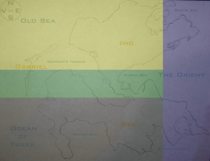
Gabriel
The average temperature is 20°C with little precipitation. The islands of Gabriel ( from north to south ) are Lebanon, Tehran, and Gaza. There's little differentiation between the seasons. Gabriel divides the Old Sea and the Serpent's Tongue. This area is vulnerable to earthquakes.
Imo
Imo has an average temperature of 16°C with moderate precipitation. Summers are hot, humid and short. Winter is usually a short season as well, only moderately chilling. In the extreme north-east are the Baffin Mountains (8,800 m), the only major mountain range in Imo. The Ali'a Plateau extends from the Old Sea to The Orient, and is known to be the most fertile farming land in the nation. Between the Floral Sea and Serpent's Tongue are the Floral Plains, a low lying area responsible for draining flood water into the sea.
Sek
Sek has an average temperature of 4°C with a heavy amount of precipitation year round. The continent experiences very cold winters, with short cool summers. Extending south from the Imo juncture are the Floral-Winter Mountains (4,400 m), and along the eastern coast are the Orient-Knight Mountains (5,600 m). The Kach Basin (Central Sek) separates the mountains, and consists mostly of tundra. To the south-east are Knight Waters which remain frozen indefinitely. Winter Sea deteriorates in the summer. Western Sek is generally more habitable with accommodation highlands and little gradient. The Ocean of Tweek is off the east, the Serpent's Tongue is off the north.
Political Divisions
The Federation Definition Act ( P001ƒ ) created the federal structure known today, and delegated authority to the various administrative institutions created. It established clear definitions as to the excercise of authority, and legal boundaries.
| District |
|---|
| A symmetrically proportioned administrative division, five hundred kilometers in length by five hundred kilometers in width ( 500 km. x 500 km. ). The exception to these proportions are islands which are classified as a district regardless of size. A coastal district includes the water which lay within its boundaries. A district is appointed a marhsall by Imperial House to conduct required administrative actions. |
| Ward |
| An administrative division proportioned according to population ( one created for every tenth percent of the national population ). Each Ward is granted a speaker in Popular House to be decided upon by election. A ward can represent several cities, part of a city, or thousands of plantations depending upon population. |
| City |
|---|
| Imperial House entrusts a City Charter to communities which reach certain residential, commercial, and cultural standards. Greater autonomy is bestowed upon a community with a City Charter along with various inticing government programs. |
| Arrondissement |
| An Arrondissement is a smaller federal administrative district defined by City administration within their charter. |
| Plantation |
|---|
| A chartered community encompassing a significant territory with few inhabitants. A plantation is presided over by a Warden, elected by the residents of the plantation. |
Climate system
Fodist Domestic Standard Climate Protocol
| Protocol | Characteristics |
|---|---|
| Emulov-Nokonagol Protocol | 16°C-14°C average (High 20°C Low 12°C), warm and humid, little precipitation |
| Cairo Protocol | 14°C-10°C average (High 16°C Low 8°C), cool and dry, moderate precipitation |
| Woods-Tweek Protocol | 10°C-6°C average (High 12°C Low 4°C), cold and dry, heavy precipitation |
| Baffin-Knight Protocol | 6°C-2°C average (High 8°C Low 0°C), severe precipitation |
