Difference between revisions of "Bevanbrook Province"
(→Sport) |
(→Sport) |
||
| Line 208: | Line 208: | ||
*Holvinghill | *Holvinghill | ||
*Hathuntwick | *Hathuntwick | ||
| + | |||
| + | ==Physical geography & Climate== | ||
| + | |||
| + | The climate of Bevanbrook is cold oceanic near the coast. The island’s position in the Holdonian Sea ensures that it lies in the path of the North Holdonian Current, which makes the climate of the island more temperate than may be expected of its latitude. The weather in Bevanbrook can be notoriously variable. | ||
| + | |||
| + | ===Winter=== | ||
| + | |||
| + | The Bevanbrook winter is relatively mild in comparison to its latitude. The southerly lowlands of the island average around 0°C in winter, whilst the highlands tend to average around –10°C. The lowest temperatures in the northern part of the island range from around –25°C to –30°C. The lowest temperature on record is –39.7°C. | ||
| + | |||
| + | ===Summer=== | ||
| + | |||
| + | The average July temperature in the southern part of the island is 18°C. Warm summer days can reach 20–25ºC. The highest temperature recorded was above 30°C. | ||
==Sport== | ==Sport== | ||
Latest revision as of 17:54, 18 October 2007
| Bevanbrook Province | |
 |
|
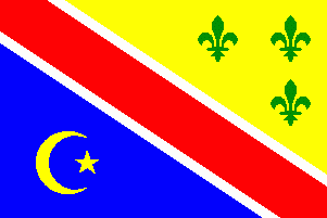
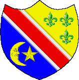
| Provincial flag | Provincial Coat of Arms |
| Motto | A Mari Usque Ad Mare. |
| Lord Protector of Bevanbrook | Sir Francis Le Mordervale |
| Nation | Kingdom of St Samuel |
| Provincial Capital | Covington |
| Population - Total (2007) |
38,197,000 |
| Districts | 8 |
Bevanbrook is an island of St Samuel and federal province located in the Holdonian Sea, north-west of mainland St Samuel. The current Lord Protector of Bevanbrook is Sir Francis Le Mordervale.
Contents
History
Government
The current Lord Protector of Bevanbrook is Sir Francis Le Mordervale.
Economy
The economy of Bevanbrook is based principally on agriculture. A wide variety of products are produced, both for domestic consumption and use as well as for export throughout St Samuel and the world. They include dairy products, eggs, fruits, vegetables, decorative foliage and more. There are also many manufactured goods made from raw agricultural materials, mostly for domestic use because strict laws restricting the use of chemical preservatives limits long-distance export of some products. However, those same restrictions make the local products such as baked goods and meats highly prized by people visiting from afar.
The most significant industrial export of is oil. Large off-shore oil reserves are located off the south coast of Bevanbrook, where oil companies have been extracting oil since the 1970's.
Demographics
Population
The population of Bevanbrook is 38,197,000.
Ethnicity
Latin - 52%, White - 19%, Mixed-White & Black - 17%, Arab - 9%, Black - 3&
Religion
Roman Catholic - 78%, Orthodox Christian - 8%, Muslim - 7%, Protestant - 7%
Geography
Districts of Bevanbrook:
- Lamb's Cove
- Yves
- Santoval
- Auburn
- Summis
- Grennych
- Lynneboro
- Wyannoch
Lamb's Cove
- Covington
- Bristol
- Clifton
- Drexel
- Salem
- Burlington
- Clearwater
- North Point
- Nichols
- Easton
- Woolrich
Yves
- Lawrence
- Yves City
- Elgin
- Hawsingwood
- Puttivstead
- Lingarvbrook
- Tollissbluff
- Ersyrheath
- Walingthorp
- Woolvenbluff
- Tisingheath
- Cherswick
- Chassevwich
Santoval
- Chatham
- Ridge Park
- Thilterton
- Hinghfalls
- Grickesley
- Hengfalls
- Terowood
- Wilbickbury
- Singhdale
- Wollingbrook
- Cublingminster
Auburn
- Fourtania
- Skinghbury
- Berompmoor
- Lingiggwood
- Arringdale
- Asingbury
- Wolverpool
- Sprumpickwich
- Atingham
- Perston
- Horrsstead
Summis
- Paxton
- Delano
- Carleton
- Eringbury
- Upleaddiwick
- Wymiddstone
- Linghbluff
- Pingarvbluff
- Hibemwood
- Heringheath
- Bolingthorp
- Hurlarbluff
- Thanghwich
Grennych
- Hampton
- Greenburg
- Shelby
- Cape Magee
- Loganton
- Linghgrove
- Racklegrove
- Ovingwood
- Gresingbury
- Ocklingham
- Maringfield
- Follongdon
- Erilsstead
- Dinghstone
- Hitlsdale
Lynneboro
- Lynne
- Kennsington
- Crescent Beach
- Steroatfield
- Billodddale
- Minghminster
- Plywilbfield
- Wigguisgrove
- Bullinghill
- Roitaughfield
- Hemingstead
- Linghfield
- Houghurgwich
Wyannoch
- Myo Beach
- Golic
- Connorton
- Exeter
- Port Harding
- Port Gennary
- Abbingham
- Wilboshill
- Andringdale
- Gringford
- Beringwich
- Testwich
- Bickerdale
- Helvelfield
- Holvinghill
- Hathuntwick
Physical geography & Climate
The climate of Bevanbrook is cold oceanic near the coast. The island’s position in the Holdonian Sea ensures that it lies in the path of the North Holdonian Current, which makes the climate of the island more temperate than may be expected of its latitude. The weather in Bevanbrook can be notoriously variable.
Winter
The Bevanbrook winter is relatively mild in comparison to its latitude. The southerly lowlands of the island average around 0°C in winter, whilst the highlands tend to average around –10°C. The lowest temperatures in the northern part of the island range from around –25°C to –30°C. The lowest temperature on record is –39.7°C.
Summer
The average July temperature in the southern part of the island is 18°C. Warm summer days can reach 20–25ºC. The highest temperature recorded was above 30°C.
Sport
The most popular sports in Bevanbrook with the largest followings are football, baseball, curling and rugby.


