Legalese Highway System
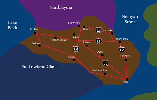
The Legalese Highway system is a series of expressways, connecting the major cities of Legalese. The routes included are as follows:
 , aka. Federal Trail: East-West Highway Stretching from Francopolis to Pt. Dien. Runs through the capital at Iudica.
 , aka. Eastern Expressway: North-South Highway connecting Francopolis to Myre, running through Gavelton on the way.
 , aka. Northern Connection: East-West Highway connecting from the Starblaydi border at Snowcroft to Tiberia, eventually ending in Numalia.
 , aka. Central Expressway: North-South Highway extending from Snowcroft down to the border of the Legal Republic of The Lowland Clans. other than Snowcroft, the only major city served by L4 is Curia.
 , aka. Diagonal Road: The only Legalese Highway to run diagonally, the L6 runs SouthEast-NorthWest, connecting Myre to Iudica, ending at the intersection of L1 and L4.
There is also the Unsigned Southern Expressway, which runs East-West, connecting Myre to Southampton, jutting off at the Lowland Clans border, intersecting L4 just north of Curia, running through Bellona, and ending in Pt. Dien.
Here is a full map of the highway system:

