The Province of Algar

Contents
Geography
Algar is in western Domonia, it borders the nation of Antrium along the River Isca. Eastwards it borders the province of Powysia. To the south west, its border with Hiel follows the line of peaks of the Hiel Mountain range, which runs northwesterly, until it reaches the Antrium border. South of Algar are the provinces of Inlad and Sendar.
With the exception of the southern section, the province is well watered. Algar contains a few rivers and lakes ideal for swimming, water skiing, fishing and a full range of other water sports.
As Algar extends many kilometres from north to south, and east-west, it is natural that the climate should vary considerably. It is also further influenced by the different altitudes above sea level of the different parts of the province.
Northern Algar has fewer frost-free days than southern Algar, which is almost desert-like in its summer heat and lack of rain. Western Algar is protected by the mountains, and enjoys the warmth brought by winter chinook winds, while eastern Algar is flat, dry prairie, where temperatures can range from very cold (−35°C (−31°F) in the winter) to very hot (+35°C (+95°F) in the summer). Central and southern Algar are the most likely places in Domnonia to experience tornadoes because of the summer heat, and violent summer thunderstorms are common in the eastern half of the province.
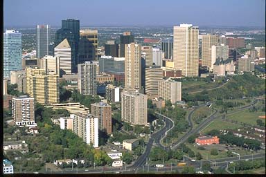
Algar's capital city, Algaria, is located almost exactly in the centre of the province, and most of Algars's vast oil resources are refined here. Southern Algar, where Dunum is located, is known for its ranching, and cattle run free through the whole winter. Much of the unforested part of Algar is given over either to grain or to dairy farming, with ranching predominantly a southern Algar industry.
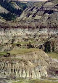
In southeastern Algar, where the Powysia River seperates the province from its neighbour and traverses flat prairie and farmland, are the Domini badlands with deep gorges and striking landforms. Fossil National Park, near Venta, Algar, showcases the badlands terrain, desert flora, and remnants from Algar's past when dinosaurs roamed the then lush landscape.
Overall, Algar has cool winters, with a daytime average of about −10°C (14°F) in the south to −24°C (−12°F) in the north. In the summer the temperature averages about 13°C (55°F) in the Hiel Mountains and 18°C (64°F) in the dry prairie to the south-east.
Algar is fortunate to have an extensive northern maritime coast.
Cities and Municipalities
Largest municipalities and metro areas by population
| Municipality | 2005 | 2001 | 1996 |
|---|---|---|---|
| Metropolitan Areas: | |||
| Algaria | 1,060,300** | 951,395 | 821,628 |
| Isca | 1,016,000** | 937,845 | 862,597 |
| Cities (10 Largest): | |||
| Algaria | 956,078 | 878,866 | 768,082 |
| Isca | 712,391 | 666,104 | 616,306 |
| Aelle | 79,082 | 67,707 | 60,080 |
| Trent | 77,202 | 67,374 | 63,053 |
| Pontes | 56,318 | 53,081 | 46,888 |
| Lloegyr | 56,048 | 51,249 | 46,783 |
| Benoic | 44,631 | 36,983 | 31,353 |
| Dunum | 27,069 | 20,382 | 15,946 |
| Camlann | 18,405 | 15,983 | 14,271 |
| Glevum | 15,850 | 14,854 | 13,728 |
| Districts (3 Largest by Land): | |||
| Algar East Maritime County | 80,232 | 71,986 | 64,176 |
| Woodland Hiel Rise County | 73,176 | 41,466 | 35,213 |
| Domini Badlands Rural Municipality | 30,688* | 28,441 | 23,326
</b> </table> Sources: All 2005 figures are based on official 2005 census data from municipalities. Where no 2005 data is available, (*) indicates the most recent official data from either the municipality or the 2001 Statistics Domi federal census. All data for 2001 and 1996 is from the respective federal census. Metro Area data is from the most recent Statistics Domi estimate. (**) indicates 2005 Metro Area estimates according to Statistics Domi IndustryAgricultureGovernmentEducationCultureFlauna and Flora== Headline text == |


