Difference between revisions of "The Burnsian Desert"
(→Geography) |
|||
| Line 73: | Line 73: | ||
| − | The Burnsian Desert was formed during the Iranian (Then Persia) occupation of India (1648-1847). In 1702, British expatriot Orville Burns created the '''"Burnsian Seccession Organisation"''', whose goal was to create a soverign state made up of Arabs, Indians and Britons in South India. After several bloody years of civil war, the Persian government agreed to cede a small polyp of Indian coastline to the BSO. Since this land was so barren and inhospitable (it was located on the tip of today's Al-Samarra Peninsula), the local news outlets coined it "The Burnsian Desert". Orville ratified the name in the [[Burnsian Charter]], some say as a joke. Nevertheless, as time went on, conquest by an increasingly powerful BSO expanded the borders and formed what is now known, modernly, as The Burnsian Desert. TBD is run by an autocratic ruler who changes frequently due to political and military infighting. The leader with the record for the longest term is '''President-General Mitchell C. Craig'''. | + | The Burnsian Desert was formed during the Iranian (Then Persia) occupation of India (1648-1847). In 1702, British expatriot Orville Burns created the '''"Burnsian Seccession Organisation"''', whose goal was to create a soverign state made up of Arabs, Indians and Britons in South India. After several bloody years of civil war, the Persian government agreed to cede a small polyp of Indian coastline to the BSO. Since this land was so barren and inhospitable (it was located on the tip of today's Al-Samarra Peninsula), the local news outlets coined it "The Burnsian Desert". Now referred to as King, Orville ratified the name in the [[Burnsian Charter]], some say as a joke. Nevertheless, as time went on, conquest by an increasingly powerful BSO expanded the borders and formed what is now known, modernly, as The Burnsian Desert. TBD is run by an autocratic ruler who changes frequently due to political and military infighting. The leader with the record for the longest term is '''President-General Mitchell C. Craig'''. |
==Geography== | ==Geography== | ||
| Line 81: | Line 81: | ||
* [http://i133.photobucket.com/albums/q59/sa7kix/MilitaryMapPNG.png Military Bases] | * [http://i133.photobucket.com/albums/q59/sa7kix/MilitaryMapPNG.png Military Bases] | ||
| − | === | + | ===Geographic Notes=== |
| + | |||
| + | '''Area''' | ||
* Total: 7,982,711 sq.km. | * Total: 7,982,711 sq.km. | ||
* Land: 7,882,121 sq.km. | * Land: 7,882,121 sq.km. | ||
* Sea: 100,590 sq.km. | * Sea: 100,590 sq.km. | ||
| − | + | '''Climate''' | |
| + | |||
Mostly hot and wet in the Peninsulas and Western Mountain provinces, but hotter and drier in the Central Desert and Mountain provinces. | Mostly hot and wet in the Peninsulas and Western Mountain provinces, but hotter and drier in the Central Desert and Mountain provinces. | ||
| − | + | '''Elevation Extremes''' | |
* Highest Point: Mt. Al-Futan (10,401 ft.) | * Highest Point: Mt. Al-Futan (10,401 ft.) | ||
* Lowest Point: Icarus Valley (-7 ft.) | * Lowest Point: Icarus Valley (-7 ft.) | ||
| − | + | '''Natural Resources''' | |
| + | |||
Coal, petroleum, natural gas, uranium, luxury minerals, silicon, sulfur, wood products, rubies, bauxite, copper, silver | Coal, petroleum, natural gas, uranium, luxury minerals, silicon, sulfur, wood products, rubies, bauxite, copper, silver | ||
| − | + | '''Natural Hazards''' | |
| + | |||
Open sulfur pits, cyclones along the coast, ultraviolet exposure in the desert and mountain regions, tornadoes in the Al-Qu'tan Plains, dense marshlands in the Kalidian Lowlands | Open sulfur pits, cyclones along the coast, ultraviolet exposure in the desert and mountain regions, tornadoes in the Al-Qu'tan Plains, dense marshlands in the Kalidian Lowlands | ||
| − | === | + | ===Culture=== |
| + | |||
| + | A relatively young nation, The Burnsian Desert has not had ample time to develop its own culture. However, the cultures of India, Iran and Britain are all represented heavily in the country. British styles of clothing are most prevalent, while the food is mostly Indian. Cultures around country are quite cohesive, and there are almost no racial ghettoes or discrimination, especially in the large cities. Royalty Day is the premiere holiday of the season, economically and culturally. The military follows a unique fusion of American, Iranian and British organizational doctrines. | ||
| + | |||
| + | |||
| + | ===Ethnicity=== | ||
| + | |||
| + | [http://i133.photobucket.com/albums/q59/sa7kix/Ethnicity.png|Right] | ||
| + | '''African-Burnsian:''' 0.21% | ||
| + | |||
| + | '''Latino:''' 17.02% | ||
| + | |||
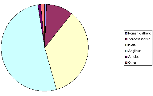
| + | ===Religions=== | ||
| + | |||
| + | http://i133.photobucket.com/albums/q59/sa7kix/Religions.png | ||
Revision as of 21:11, 23 December 2006
| |||
| National motto: "World's Largest Producer of Radioactive Plate Glass" | |||
| National anthem: "O Glorious Desert" | |||
| Political Map | |||
| Topographic Map | |||
| Region | Lazarus | ||
| Capital | Highfather | ||
| Largest City | Regal | ||
| Population | 6.0 Billion | ||
| Suffrage | N/A | ||
| Official Language(s) | English, Arabic | ||
| Government President-General
|
Socialist-Monarchy Mitchell C. Craig | ||
| Holidays Independence Day Military Day Royalty Day |
July 11 November 20 May 10 | ||
| ISO Nation Code | TBD | ||
| Currency | Burned Note (BRN)
| ||
| Time Zone • Summer (DST) |
GMT -4:00 GMT -5:00 | ||
| Internet TLD | .tbd | ||
| Calling Code | +12
| ||
| National Symbols • Sport • Animal • Fruit • Flower |
Soccer Monkey Pomegranate Sunburst Lily | ||
| UN Status | Expelled | ||
| Info: NationStates NSEconomy Pipian NS Tracker XML | |||
The Burnsian Desert was formed during the Iranian (Then Persia) occupation of India (1648-1847). In 1702, British expatriot Orville Burns created the "Burnsian Seccession Organisation", whose goal was to create a soverign state made up of Arabs, Indians and Britons in South India. After several bloody years of civil war, the Persian government agreed to cede a small polyp of Indian coastline to the BSO. Since this land was so barren and inhospitable (it was located on the tip of today's Al-Samarra Peninsula), the local news outlets coined it "The Burnsian Desert". Now referred to as King, Orville ratified the name in the Burnsian Charter, some say as a joke. Nevertheless, as time went on, conquest by an increasingly powerful BSO expanded the borders and formed what is now known, modernly, as The Burnsian Desert. TBD is run by an autocratic ruler who changes frequently due to political and military infighting. The leader with the record for the longest term is President-General Mitchell C. Craig.
Geography
Maps
Geographic Notes
Area
- Total: 7,982,711 sq.km.
- Land: 7,882,121 sq.km.
- Sea: 100,590 sq.km.
Climate
Mostly hot and wet in the Peninsulas and Western Mountain provinces, but hotter and drier in the Central Desert and Mountain provinces.
Elevation Extremes
- Highest Point: Mt. Al-Futan (10,401 ft.)
- Lowest Point: Icarus Valley (-7 ft.)
Natural Resources
Coal, petroleum, natural gas, uranium, luxury minerals, silicon, sulfur, wood products, rubies, bauxite, copper, silver
Natural Hazards
Open sulfur pits, cyclones along the coast, ultraviolet exposure in the desert and mountain regions, tornadoes in the Al-Qu'tan Plains, dense marshlands in the Kalidian Lowlands
Culture
A relatively young nation, The Burnsian Desert has not had ample time to develop its own culture. However, the cultures of India, Iran and Britain are all represented heavily in the country. British styles of clothing are most prevalent, while the food is mostly Indian. Cultures around country are quite cohesive, and there are almost no racial ghettoes or discrimination, especially in the large cities. Royalty Day is the premiere holiday of the season, economically and culturally. The military follows a unique fusion of American, Iranian and British organizational doctrines.
Ethnicity
[1] African-Burnsian: 0.21%
Latino: 17.02%
Religions

![[1]](http://i133.photobucket.com/albums/q59/sa7kix/Ethnicity.png%7CRight)