Chur River
| Chur | |
|---|---|
|
Chur River | |
| Origin | Moritz Gletscher, Mikitivity |
| Mouth | Risden River |
| Basin countries | Mikitivity |
| Length | ? |
| Source elevation | 2,500 m |
| Avg. discharge | ? |
| Watershed area | ? |
The Chur River is an entrenched tributary of the Risden River. It is fed by year-round snow and ice melt from the Moritz Gletscher located high in the Thuvian Mountains. The river forms the boundary between Miervatia and Nolanstadt cantons in Mikitivity. The tight gorge it cuts out of the mountains in its headwaters, has lead many to consider it one of the most scenic rivers in NationStates and one of the coldest rivers in Mikitivity. The river also carries significant building aggragate out of the mountains down to the valley floor, including marble blocks.
Contents
Geography and Course
Headwaters
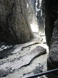
The source of the Chur is the Moritz Gletscher located in Miervatia canton. The glaicer extends over the southern reaches of the Thuvian Mountains. Glaicer melt converges in a narrow gorge between the Bernhorn and Sudwand peaks to form the initial source of the Chur. In the entire upper watershed, the Chur is characterized by the gorge it has cut between the Thuvian peaks.
Confluence / Destination
The Chur meets the Risden River upstream of the city of Grupta. The river carries a high mineral load and low organic load to mix with the Risden, and thus at the confluence of the two rivers the Risden's color becomes a chalky white.
Physical Characteristics
Ecology
The cold waters from the snow and ice runoff that feed the Chur do not provide adequate habitat for many fresh water fish species, however, the native Musk Pike has adapted to the cold water and low light conditions.
