Difference between revisions of "Kastelorizo"
(→Geography) |
(→Geography) |
||
| (3 intermediate revisions by the same user not shown) | |||
| Line 15: | Line 15: | ||
== Geography == | == Geography == | ||
| − | '''Geology and Topography''' | + | '''Geology and Topography:''' |
| − | The kastelorizean territory, while not vast, is a variative one. The mountainous north, peaking altitudes of 700 meters, contrasts with the soft hills and beaches of the center-south. The first, mostly of vulcanic origin, is composed by two mountain ranges | + | The kastelorizean territory, while not vast, is a variative one. The mountainous north, peaking altitudes of 700 meters, contrasts with the soft hills and beaches of the center-south. The first, mostly of vulcanic origin, is composed by two mountain ranges: the smaller, vendian-period, Toluka, and the vast and neovulcanic Dhusara. The southern portion, 84% of which is at sea level, has homogeneous landscape. The island as a whole shares the same limestone latosoil, consisting a total of 1721 square meters of surface. |
| + | While mostly regular, the coast splits into 2 shallow-water bays, the largest of which holds Kastelorizos most-populated and capital city, Megisti. It also features a single southern cape that communicates with the province of Propylea, a small but numerous archipelago of sandy islands. | ||
| + | Aside from Propylea, the kingdom also holds under its influence the islets of Kalamaki, Kekova and the inhabited Dhassia. | ||
| − | + | '''Climate:''' | |
| − | + | In spite of the higher altitudes suffer with higher wind velocities and ocasional orographic rain, the island is climatically similar. Due to proximity to the equator, both summer and winter temperatures are high. The rain regime, however, varies intensively, | |
Latest revision as of 16:28, 18 June 2007

| |
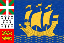
| Flag of Kastelorizo | |
| Motto: "We can always work less" | |

| |
| Region | Greece |
|---|---|
| Capital | Megisti |
| Official Language(s) | Greek |
| Leader | Guillerme III d'Valois |
| Population | 230 Million |
| Currency | Dalmasca |
| NS Sunset XML | |
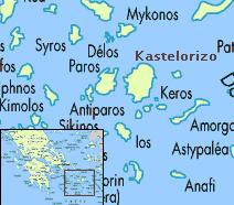
Enviromentally stunning and popular turist hot-spot, The Kingdom of Kastelorizo is a small nation situated in the Island of Naxos, located roughly 180 kilometers SE off the coast of Athens. Once a feudal province of the Agevin, its independence was made possible with the prosperity brought by the pivotal position assumed during the Cicladian Wars, complemented by the embryo of what would be Kastelorizos true XIVth century gold mine, Spice trading. The peaceful kingdom now boasts a condition stablished over centuries of greek tradition, standing as political and cultural center of its region.
Geography
Geology and Topography: The kastelorizean territory, while not vast, is a variative one. The mountainous north, peaking altitudes of 700 meters, contrasts with the soft hills and beaches of the center-south. The first, mostly of vulcanic origin, is composed by two mountain ranges: the smaller, vendian-period, Toluka, and the vast and neovulcanic Dhusara. The southern portion, 84% of which is at sea level, has homogeneous landscape. The island as a whole shares the same limestone latosoil, consisting a total of 1721 square meters of surface. While mostly regular, the coast splits into 2 shallow-water bays, the largest of which holds Kastelorizos most-populated and capital city, Megisti. It also features a single southern cape that communicates with the province of Propylea, a small but numerous archipelago of sandy islands. Aside from Propylea, the kingdom also holds under its influence the islets of Kalamaki, Kekova and the inhabited Dhassia.
Climate: In spite of the higher altitudes suffer with higher wind velocities and ocasional orographic rain, the island is climatically similar. Due to proximity to the equator, both summer and winter temperatures are high. The rain regime, however, varies intensively,
