National Highway System (Antrium)
The National Highway System of Antrium is a network of freeways in Antrium. They are funded by the Antrian government, through taxes. They are intended to promote easy travel through the country of Antrium.
The National Highway System is often referred to as the NHS. Highways in this system are named by "AN-number." AN is the IDU nation code for Antrium, and the number indicates which highway you are on. There are currently 8 highways in the National Highway System.
Unlike other systems, these highways often serve the downtown areas of major cities, to accomodate traffic from the suburbs to the commercial centers of a city.
History
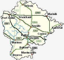
The original plans for the National Highway System ([1]) were approved by Parliament on September 3, 2005. Interest in a freeway network came after the International Democratic Union was considering a plan for a regional network of freeways. The original plan included highways AN1-AN5.
After the discovery of the province of Alvés-Navlan, NHS officials planned the addition of AN6, from Balton to Marnezjalis.
When the Antrian government annexed three additional provinces on February 18, 2006, the National Highway System Administration (NHSA) started planning new highways to serve the new area. These plans were finished on May 21, 2006, and are shown above. This plan added two new highways, AN7 and AN8, and extended AN2, AN4, and AN5.
Standards
The standards for highways in the NHS are set by the NHSA. They have decided that the highways will be entirely free to use, that there may not be stop lights on any NHS highway,
Lanes
All highways in the NHS must have at least four lanes, two in each direction. Some highways have six lanes, or even more, through urban areas, to accomodate the large amount of traffic there.
During an emergency situation, lanes can be reversed to go from incoming to outgoing, to allow for quick evacuation of an area.
Speed limits
The speed limit for all NHS highways is 110 kilometers per hour, or about 70 miles per hour. This may be lower in some urban areas, but the speed limit on a NHS highway is never lowered below 95 kilometers per hour, unless there is road construction or lane closures.
Signage
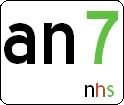
NHS highways are signed by a white, rectangular sign, with the letters "AN" in black, and the number in lime green. The letters "NHS" appear in the lower right corner, in the colors of the Antrian flag: lime green, dark red, and black.
Exits are numbered by their location, corresponding to kilometer markers. Exit numbers usually follow the pattern "Province code - Kilometer number - letter. (if multiple exits in 1 km)" The kilometer number starts from the north on a north-south highway, and from the west on a west-east highway.
Province codes are "NO" for Norato, "SO" for Soréto, "VE" for Véo, "SI" for the District of Sivaris, "ES" for Esto, "AL" for Alvés-Navlan, "LK" for Lakitéo, "KT" for Kostatero, and "MV" for Monvelàro.
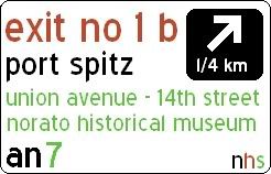
The exit sign gives the exit number at the top in Antrian red, the name of the nearest city in black underneath, followed by the street or highway name and nearby attractions in green. At right, a black box shows an arrow showing the direction of the exit with the distance until the exit underneath in white. At the bottom is the name of the NHS highway you are currently on, and "NHS" in the right hand corner. A sample sign is shown at left.

Small square signs, called kilometer markers, appear at every kilometer, to alert you to which kilometer you are on. This information is helpful in determining the distance to the exit you will take. These signs are white, with "NHS" in the lower right corner, and the kilometer number in black in the center.
Additional Materials
Plans for new National Highway System approved The Antrium Beacon-Times
Plans for NHS additions unveiled The Antrium Beacon-Times

![[1]](http://photos1.blogger.com/blogger/5948/1443/1600/map_nhs.jpg)