Difference between revisions of "Esto (province)"
| Line 13: | Line 13: | ||
== History == | == History == | ||
| + | The province of Esto was once in the former nation of American Federalist, where it was split into three provinces: Esto, North Hiel, and Ituri. Federalist Esto also included much of the Antrian provinces of [[Monvelàro]] and [[Kostatero]]. | ||
| + | |||
| + | During the [[American Federalist/Riconiaa Refugee Crisis]], Esto was where much of the crisis' brutal violence occured. Many refugees attempting to escape the destroyed country tried to flee to [[Domnonia]] through Esto. Many made it, while about 9,000 were killed by the Nationalist and Integrationalist Front. | ||
| + | |||
| + | It was one of the first four provinces of Antrium, along with [[Norato]], [[Soréto]], and [[Véo]]. | ||
== Geography == | == Geography == | ||
| + | Western Esto is in the [[Granvéo Mountains]], having some of the largest mountains in the country. Most of central Esto is made up of highlands, with very few rivers. The land gets drastically lower on the easternmost edge of Esto, where the land lowers off towards the East Union Sea. | ||
== Counties == | == Counties == | ||
{{image|http://i31.photobucket.com/albums/c377/antrium/estocounties.jpg|left|A map of the counties of Esto|The counties of Esto}} | {{image|http://i31.photobucket.com/albums/c377/antrium/estocounties.jpg|left|A map of the counties of Esto|The counties of Esto}} | ||
| + | Esto is divided into 24 counties, in three regions. Regions are not official divisions made by the Antrian government, and are only used to describe a certain area of the province. The three regions are: Corico Area (shown in red and pink), The Highlands (shown in yellow), and East Sivaris (shown in blue). The names of each county are shown on the map at left. | ||
== Cities == | == Cities == | ||
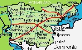
{{image|http://i31.photobucket.com/albums/c377/antrium/estoprovincial.jpg|left|A map of Esto|A map of Esto}} | {{image|http://i31.photobucket.com/albums/c377/antrium/estoprovincial.jpg|left|A map of Esto|A map of Esto}} | ||
| + | The largest city in Esto is [[Corico]], with a population of 4.8 million. Second is Inatra, with 1.3 million, and third is Onvîrû, with 712,000. | ||
== Transportation == | == Transportation == | ||
| + | Esto is home to three of Antrium's [[National Highway System (Antrium)|national highways]]: AN1, running east-west from [[Sivaris]] to Îķtàbréo, AN5, running northwest from Balton through Corico into [[Monvelàro]], and AN7, heading southeast from [[Anvàln]] to Corico. | ||
| + | |||
| + | There are also many provincial highways, shown in teal, and county highways, shown in grey. | ||
== Education == | == Education == | ||
| + | There are many universities and colleges in Esto, including the University of Esto, which has locations in Corico and Inatra. | ||
[[Category:Provinces]] | [[Category:Provinces]] | ||
[[Category:Antrium]] | [[Category:Antrium]] | ||
Revision as of 14:18, 29 October 2006
This article is incomplete because it is pending further input from participants, or it is a work-in-progress by one author.
Please comment on this article's talk page to share your input, comments and questions.
Note: To contribute to this article, you may need to seek help from the author(s) of this page.
This article is about the Antrian province. For other uses of this name, see Esto (disambiguation).
| Esto (province) | ||||||
|---|---|---|---|---|---|---|
|
Esto is a province in eastern Antrium. It is one of the five Original Provinces of Antrium.
History
The province of Esto was once in the former nation of American Federalist, where it was split into three provinces: Esto, North Hiel, and Ituri. Federalist Esto also included much of the Antrian provinces of Monvelàro and Kostatero.
During the American Federalist/Riconiaa Refugee Crisis, Esto was where much of the crisis' brutal violence occured. Many refugees attempting to escape the destroyed country tried to flee to Domnonia through Esto. Many made it, while about 9,000 were killed by the Nationalist and Integrationalist Front.
It was one of the first four provinces of Antrium, along with Norato, Soréto, and Véo.
Geography
Western Esto is in the Granvéo Mountains, having some of the largest mountains in the country. Most of central Esto is made up of highlands, with very few rivers. The land gets drastically lower on the easternmost edge of Esto, where the land lowers off towards the East Union Sea.
Counties
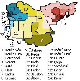
Esto is divided into 24 counties, in three regions. Regions are not official divisions made by the Antrian government, and are only used to describe a certain area of the province. The three regions are: Corico Area (shown in red and pink), The Highlands (shown in yellow), and East Sivaris (shown in blue). The names of each county are shown on the map at left.
Cities
The largest city in Esto is Corico, with a population of 4.8 million. Second is Inatra, with 1.3 million, and third is Onvîrû, with 712,000.
Transportation
Esto is home to three of Antrium's national highways: AN1, running east-west from Sivaris to Îķtàbréo, AN5, running northwest from Balton through Corico into Monvelàro, and AN7, heading southeast from Anvàln to Corico.
There are also many provincial highways, shown in teal, and county highways, shown in grey.
Education
There are many universities and colleges in Esto, including the University of Esto, which has locations in Corico and Inatra.
