File:COM-locator.png
From NSwiki, the NationStates encyclopedia.
No higher resolution available.
COM-locator.png (256 × 165 pixels, file size: 26 KB, MIME type: image/png)
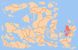
Locator map for the Unified Capitalizt States in Atlantian Oceania, circa 101 CE.
File history
Click on a date/time to view the file as it appeared at that time.
| Date/Time | Thumbnail | Dimensions | User | Comment | |
|---|---|---|---|---|---|
| current | 09:23, 17 June 2006 | | 256 × 165 (26 KB) | Commerce Heights (Talk | contribs) | Locator map for the Unified Capitalizt States in Atlantian Oceania, circa 101 CE. |
- You cannot overwrite this file.
File usage
The following page links to this file:
