Difference between revisions of "Saidercray"
| Line 16: | Line 16: | ||
== Geografy == | == Geografy == | ||
[[Image:Saidercray-map2.jpg]] | [[Image:Saidercray-map2.jpg]] | ||
| + | |||
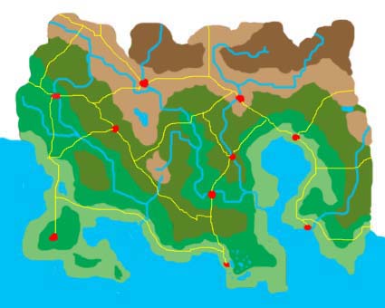
| + | Saidercray, stretching between the coast in the south and the southern Grassle Mountains in the north, is a hilly land. Its flown through by three major rivers, the Cuve splitting into Northern and Southern Cuve after it has entered the country, the Pleens flowing into the Northern Cuve short before its mouth, and the Hampet River in the east of the country. Furthermore, Saidercray contains numerous lakes. The four biggest lakes are Lake Shiwood near the west coast, the huge Lake Owlerborough in the centre, Lake Saryon in the south as the biggest lake of the Saryonan Lakeland, and Lake Welfrio near to the eastern border. | ||
Revision as of 15:52, 2 June 2006
| Flag of Saidercray | |
| Motto: Cum pace et prudentia | |
| [ ] | |
| Region | Haven of Better Tomorrow |
|---|---|
| Capital | Amshlay upon Cuve |
| Official Language(s) | English |
| Leader | Ian Woshkal |
| Population | 5 million |
| Currency | Saidercray Thaler |
| NS Sunset XML | |
The Republic of Saidercray is a democratic republic in the region of Haven of Better Tomorrow.
Geografy
Saidercray, stretching between the coast in the south and the southern Grassle Mountains in the north, is a hilly land. Its flown through by three major rivers, the Cuve splitting into Northern and Southern Cuve after it has entered the country, the Pleens flowing into the Northern Cuve short before its mouth, and the Hampet River in the east of the country. Furthermore, Saidercray contains numerous lakes. The four biggest lakes are Lake Shiwood near the west coast, the huge Lake Owlerborough in the centre, Lake Saryon in the south as the biggest lake of the Saryonan Lakeland, and Lake Welfrio near to the eastern border.

