Difference between revisions of "Saidercray"
(→Flag) |
(→Flag) |
||
| Line 33: | Line 33: | ||
=== Flag === | === Flag === | ||
| − | [[Image:Saidercray-flag.jpg]] | + | |
| + | The flag of Saidercray shows a black and a blue | ||
| + | [[Image:Saidercray-flag.jpg | The flag of Saidercray]] | ||
Revision as of 10:01, 7 June 2006
| Flag of Saidercray | |
| Motto: Cum pace et prudentia | |
| [ ] | |
| Region | International Democratic Union |
|---|---|
| Capital | Amshlay upon Cuve |
| Official Language(s) | English |
| Leader | Ian Woshkal |
| Population | 10 million |
| Currency | Saidercray Thaler |
| NS Sunset XML | |
The Republic of Saidercray is a democratic republic in the International Democratic Union.
Geografy
Landscape
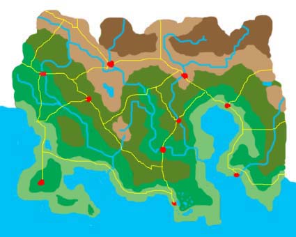
Saidercray, stretching between the coast in the south and the southern Grassle Mountains in the north, is a hilly land. Its flown through by three major rivers, the Cuve splitting into Northern and Southern Cuve after it has entered the country, the Pleens flowing into the Northern Cuve short before its mouth, and the Hampet River in the east of the country. Furthermore, Saidercray contains numerous lakes. The four biggest lakes are Lake Shiwood near the west coast, the huge Lake Owlerborough in the centre, Lake Saryon in the south as the biggest lake of the Saryonan Lakeland, and Lake Welfrio near to the eastern border. The coastline is broken through by the Green Bay in the west and the Saidercray Gulf in the east. Saidercray´s major cities are (from the west to the east): Hilngare, Cuvesbridge, Dropaney, Jallsborough, Amshlay upon Cuve, Dawsingham, Wheshpilston, Telychester, Aresgreel, Hampmouth on Sea.
Climate
Saidercray lies in the temperate zone with average temperatures of 7°C. The climate is generally humide. The wind which usually comes from west brings with it a lot of water from the sea which results into a lot of rain, especially close to the western slopes of Grassel Mountains and of their foothills. The warmest region with the lowest rainfall is the Great Central Basin. In general, western Saidercray is fresher and wetter than central and eastern Saidercray, where summers tend to be hot and in some areas even sultry. But in winter, the western lands are almost never covered with snow, which may happen in the rest of the country except for the Basin.
Geographical regions
- The Great Central Basin: The Great Central Basin, often simply called the Great Central, is a region in central Saidercray, approximately between the cities Jallsborough, Amshlay, Dawsingham and Wheshpilston. It´s the warmest and driest region of Saidercray, because most of the cool winds with water from the sea don´t make it over the Pattachoo Mountains in the west of the Great Central. The Great Central is a realtively low populated part of Saidercray with no big cities. Most of the inhabitants are farmers or have other jobs belonging to the Great Central´s strongest sector of the economy: agriculture, especially focussed on corn.


