Difference between revisions of "Mauvasia"
| Line 1: | Line 1: | ||
| − | {| border=1 align=right cellpadding=4 cellspacing=0 width= | + | <div align="center" name="Work in progress" class="boilerplate" style="background-color: #ccccff; width: 95%; margin: 0 auto; margin-bottom:8px; padding: 0 10px 0 10px; text-align: left; border: 1px solid #9B9B9B; "> |
| + | '''This page is currently incomplete.'''</div> | ||
| + | |||
| + | <div align="center" name="Feedback request notice" class="boilerplate" id="feedback" style="background-color: #CCFFCC; width: 95%; margin: 0 auto; margin-bottom:8px; padding: 0 10px 0 10px; text-align: left; border: 1px solid #9B9B9B; "> | ||
| + | '''The author(s) of this article would like constructive feedback on its content.''' <br><small>After reading the article, please comment on [[Talk:{{PAGENAME}}|{{PAGENAME}}'s talk page]] to contribute to the discussion.</small></div> | ||
| + | {| border=1 align=right cellpadding=4 cellspacing=0 width=440 style="margin: 0 0 1em 1em; background: #f9f9f9; border: 1px #aaaaaa solid; border-collapse: collapse; font-size: 95%;" | ||
|+<big><big> | |+<big><big> | ||
'''Mauvasia (The Imperial Republic of)'''</big></big><br> | '''Mauvasia (The Imperial Republic of)'''</big></big><br> | ||
| Line 24: | Line 29: | ||
|- | |- | ||
|'''[[Wikipedia:Capital|Capital]]''' || [[Darmetz]] | |'''[[Wikipedia:Capital|Capital]]''' || [[Darmetz]] | ||
| + | |- | ||
| + | |'''Largest City''' || [[Dûriandor]] | ||
|- | |- | ||
|'''Area''' <br> > Total <br> > Water | |'''Area''' <br> > Total <br> > Water | ||
| − | | <br> | + | | <br> 3,685,377 km² <br> 41,234 km² |
|- | |- | ||
|'''[[Population]]''' <br> > Total <br> > Last census <br> > Density | |'''[[Population]]''' <br> > Total <br> > Last census <br> > Density | ||
| − | | <br>over 3 billion<br>3,061,475,220<br> | + | | <br>over 3 billion<br>3,061,475,220<br>831/km² |
|- | |- | ||
|'''National Animal''' | |'''National Animal''' | ||
| Line 99: | Line 106: | ||
|} | |} | ||
| − | + | The Imperial Commonwealth Republic of '''Mauvasia''' (Mauvasian: ''La Republica à Commune Mauvasiel''; French: ''La Republique Communale de la Mauvasie'') is a large and developing nation mainly located within the largest of the four major landmasses in the region of [[Haven]], as well as a number of islands and other overseas territories within the [[Wikipedia:Pacific_Ocean|Pacific]]. The metropolitan territory of Mauvasia extends from the Haven Straits to a southern opening onto the Strobovian Sea, bordered by Dilber and Strobovia on the south and west and Tiburon on the north and covering over three million square kilometres. | |
| + | |||
| + | Mauvasia is a [[Wikipedia:Unitary_state|unitary]] [[Wikipedia:Democratic_republic|democratic republic]] with several subnational entities; its main landmass is Mauvasia proper, the Commonwealth Republic of Mauvasia. Mauvasia is a mainly isolationist nation, although it is a member of the [[Questerian Commonwealth]] and is deliberating whether or not to apply for the [[Woodstock Pact]]; it is also highly [[Wikipedia:pacifism|pacifistic]], preferring diplomacy to force when possible. | ||
| + | |||
| + | == Geography == | ||
| + | ''Main article: [[Geography of Mauvasia]]'' | ||
| + | |||
| + | Most of Mauvasia's land area is located within the mainland, "Mauvasia Proper". The mainland contains a wide variety of terrain, from open, sweeping plains, to heavily forested hills, to high and forbidding mountains. The north is mainly dominated by low, rocky hills, while western and southern Mauvasia is highly mountainous, the southern Klisurian Alps containing the highest mountain in Mauvasia, Torre-Bianco ("''The White Tower''"). Virtually every river in the country drains into the [[Dûr River|Dûr]], which splits the nation, running from south to north; this is primarily due to Mauvasia's lack of coastline, with only 178 km in the extreme northeast. | ||
| + | |||
| + | Mauvasia's largest overseas territory is [[Achraei]] (French: ''Acheroi''), located on the southernmost Haven continent in a [[Wikipedia:Subtropical|subtropical]] climate; Achraei is home to some 250 million citizens and is approximately three hundred thousand square kilometres in land area. Off Achraei, some 200 km to the north, is an archipelago of seven islands, [[Litauron]], of which six are permanently inhabited. | ||
| + | |||
| + | Additional small islands throughout the Pacific are considered Mauvasian territory and granted the full rights and privileges of citizens of the mainland. | ||
| + | |||
| + | == History == | ||
| + | ''Main article: [[History of Mauvasia]]'' | ||
| + | |||
| + | == Government == | ||
| + | ''Main article: [[Government of Mauvasia]]'' | ||
| + | |||
| + | == Administrative divisions == | ||
| + | == Transportation == | ||
| + | |||
| + | == Military == | ||
| + | |||
| + | == Economy == | ||
| + | |||
| + | == Demographics == | ||
| + | |||
| + | == Culture == | ||
| + | |||
| + | == See also == | ||
{{Template:Haven}} | {{Template:Haven}} | ||
[[Category:Mauvasia]] | [[Category:Mauvasia]] | ||
[[Category:Nations]] | [[Category:Nations]] | ||
Revision as of 14:36, 9 May 2006
After reading the article, please comment on Mauvasia's talk page to contribute to the discussion.
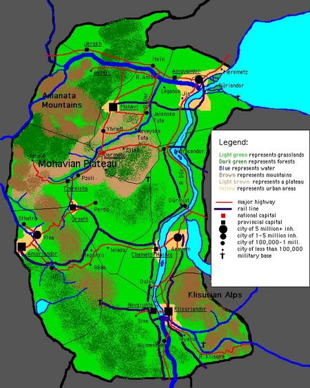
| |||||||
| Map of Mauvasia | |||||||
| General Information | |||||||
| Motto > English |
Gloriam sapientes possidebunt. The wise shall possess glory. | ||||||
| Official Languages | Mauvasian, French | ||||||
| Capital | Darmetz | ||||||
| Largest City | Dûriandor | ||||||
| Area > Total > Water |
3,685,377 km² 41,234 km² | ||||||
| Population > Total > Last census > Density |
over 3 billion 3,061,475,220 831/km² | ||||||
| National Animal | Mohave scorpion (Scorpionis mauvasii) | ||||||
| National Bird | Pelican (family Pelecanidae) | ||||||
| National Tree | Mauvasian pine (Pinus sapientis) | ||||||
| Independence | May 9, 1855 | ||||||
| Time Zone | GMT +10 | ||||||
| Naval Craft Classification | MIRS (Mauvasian Imperial Republican Ship) | ||||||
| Internet TLD | .mv (standard) .mir (government) | ||||||
| Government Details | |||||||
| Head of State | President Jonathan Jacobi | ||||||
| Head of Government | President Jonathan Jacobi | ||||||
| Government Type | Democratic republic with extensive legislative power | ||||||
| Constitution > Written > Ratified > Effective |
September 30, 1855 February 18, 1856 March 25, 1856 | ||||||
| Social Policy | Libertarianism | ||||||
| Economic Policy | Moderate socialism | ||||||
| Government Priorities | Education (16% of GDP); Communications (10% of GDP); Environmental Protection (9% of GDP); Healthcare (9% of GDP) | ||||||
| Economic Information | |||||||
| GDP (as of May 2006) > Total > per capita |
∆126,732,000,000,000 (approx.) ∆36,738 | ||||||
| Currency | Dehavia ( ∆ ) | ||||||
| Rate of Exchange > vs. NS$ > vs. € |
∆1 = NS$1.27465 ∆1 = €0.98573 | ||||||
| Exports | Timber, clay, iron ore, copper, steel, resin, fish, cheese, antimony, arsenic, water, computer parts | ||||||
| Imports | Titanium, crude oil, coal, uranium, small arms, automobile parts | ||||||
| Trading partners | TBA | ||||||
| International Situation | |||||||
| Allies | TBA | ||||||
| Friendly Nations/Alliances | Wingarde Czardas Woodstock Pact | ||||||
| Alliances | Questerian Commonwealth | ||||||
| Stats: NSEconomy Pipian XML | |||||||

The Imperial Commonwealth Republic of Mauvasia (Mauvasian: La Republica à Commune Mauvasiel; French: La Republique Communale de la Mauvasie) is a large and developing nation mainly located within the largest of the four major landmasses in the region of Haven, as well as a number of islands and other overseas territories within the Pacific. The metropolitan territory of Mauvasia extends from the Haven Straits to a southern opening onto the Strobovian Sea, bordered by Dilber and Strobovia on the south and west and Tiburon on the north and covering over three million square kilometres.
Mauvasia is a unitary democratic republic with several subnational entities; its main landmass is Mauvasia proper, the Commonwealth Republic of Mauvasia. Mauvasia is a mainly isolationist nation, although it is a member of the Questerian Commonwealth and is deliberating whether or not to apply for the Woodstock Pact; it is also highly pacifistic, preferring diplomacy to force when possible.
Contents
Geography
Main article: Geography of Mauvasia
Most of Mauvasia's land area is located within the mainland, "Mauvasia Proper". The mainland contains a wide variety of terrain, from open, sweeping plains, to heavily forested hills, to high and forbidding mountains. The north is mainly dominated by low, rocky hills, while western and southern Mauvasia is highly mountainous, the southern Klisurian Alps containing the highest mountain in Mauvasia, Torre-Bianco ("The White Tower"). Virtually every river in the country drains into the Dûr, which splits the nation, running from south to north; this is primarily due to Mauvasia's lack of coastline, with only 178 km in the extreme northeast.
Mauvasia's largest overseas territory is Achraei (French: Acheroi), located on the southernmost Haven continent in a subtropical climate; Achraei is home to some 250 million citizens and is approximately three hundred thousand square kilometres in land area. Off Achraei, some 200 km to the north, is an archipelago of seven islands, Litauron, of which six are permanently inhabited.
Additional small islands throughout the Pacific are considered Mauvasian territory and granted the full rights and privileges of citizens of the mainland.
History
Main article: History of Mauvasia
Government
Main article: Government of Mauvasia
Administrative divisions
Transportation
Military
Economy
Demographics
Culture
See also
| Nations of Haven |
|---|
| Nations: | Allanea | Ato-Sara | Aunesia | Cravan | Edolia | Franberry | Foe Hammer | Hallad | Hamptonshire | Hattia | Hogsweat | Izistan | Jaredcohenia | Kampfers | Mauvasia | Midlonia | No_Endorse | Okielahoma| Omz222 | Praetonia | Questers | Scandavian States | Skinny87 | Velkya | Willink | Whyatica |
